Marvelous photos from 1877!
I found the first three photographs (circa 1877) in the Library of Congress collection, published by the Continent Stereoscopic Company in the series “Descriptive views of the American Continent.”
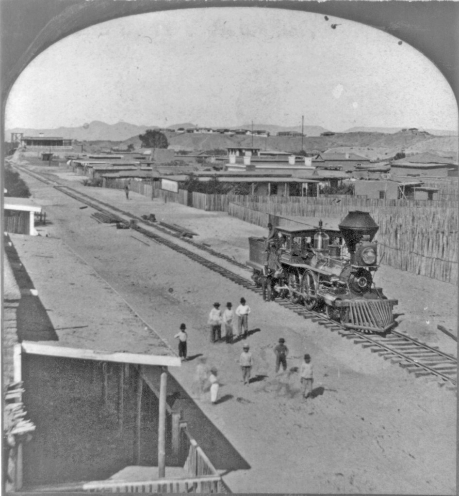
According to LoC: “Written in pen on back of mount: Fort Yuma, Cal. on bluff in background.”
I believe the shot was taken looking north from Yuma, Arizona Territory; Fort Yuma on the California side of the Colorado River can be seen on the bluff, just as the note on back reads. If you look along the tracks, you can see a glimpse of the swing bridge built by the railroad across the river.

According to LoC: “Written in pen on back of mount: Yuma, Ariz., Fort Yuma, Cal. on bluff in background.”
Looking carefully, when enlarged, the tender is has the initials “S” and “P.”
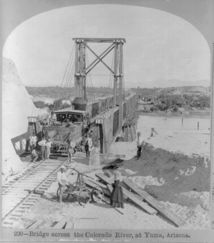
The bridge was built to swing a section aside so large boats could ply the River. Starting in 1852, steamboats were used to transport goods and people on the lower Colorado.
The Southern Pacific completed tracks from Los Angeles to Indio, California in 1876, and on to Yuma, Arizona in 1877. That year, photographer Enoch Conklin traveled in Arizona, taking his own pictures as well as acquiring photos from others. “Picturesque Arizona: Being the Result of Travels and Observations in Arizona During the Fall and Winter of 1877” was published by the Mining Record Printing Establishment, in which his pictures were credited to the Continent Stereoscopic Company. An incomplete set of the images were deposited in the LoC by an unknown source in 1907.
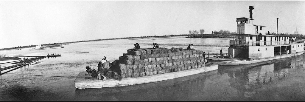
With the arrival of the Southern Pacific Railroad in 1877, steamboat travel declined. The completion of Laguna Dam in 1909, was the end of viable steamboating on the lower Colorado (see my blog entry on the Swastika Bridge for more on Laguna Dam).
Sold to the US Reclamtion Service, the Seachlight was lost on the River in October 1916; as the last steamboat on the lower Colorado, its loss ended an era.
- The copies of these two available digitally do not have the title captions, but the numbers and titles are given on the LoC information documents

The raised tracks at Yuma are interesting; it isn’t clear why this was done. Could it have been to clear floods?
The Erie tracks and platform in Elmira, NY were raised from ground level to the second floor of the station in 1933 to eliminate grade crossings. Here is a picture of the station before the tracks were raised.
The “Elmira Star-Gazette” article has a picture of the station after the tracks were raised..
https://www.stargazette.com/story/news/local/2014/10/16/elevated-railroad-elmira-history/17361667/
LikeLiked by 1 person
The tracks were built to connect to the first (in time) of three successive swing bridges that crossed the Colorado River. Before dams were built on it, the Colorado was a swift river that cut deep banks and was subject to Spring floods, especially south of its junction with the Gila River (to the northeast of the railroad bridge). Steamboats plied the River, carrying freight and passengers, and hence the swing bridges allowed them passage.
This site has some very dramatic photos of the 1916 flood:
https://www.kawc.org/post/yumas-flood-history-and-monsoon-awareness-week
Thanks for the information on Elmira; it’s wonderful to see how adaptive the railroad engineers could be!
LikeLike
I think I misinterpreted the photo. It appeared to me that the tracks were raised on a structure, but I think now I was fooled by the camera angle and the shadows.
LikeLiked by 1 person
You gave me the Elmira information, which is great. I often find really old photos can take a bit of detective work.
LikeLike