Traveling Mud Pot

Natural History in the Making

Imperial Valley Mud Pot, December 2020

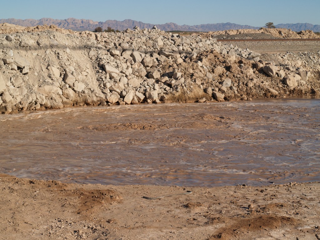
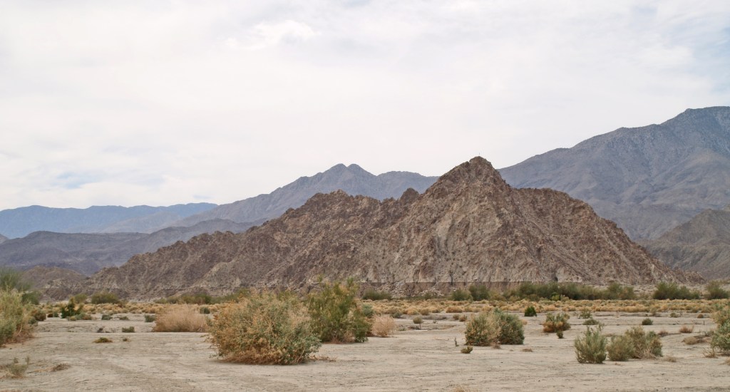
While it may not look like much, there is a traveling mud pot in Imperial Valley, California, headed toward the Salton Sea. I went down there in November 2018, when the LA Times ran an article on it (https://www.latimes.com/local/lanow/la-me-ln-niland-mud-pot-20181101-story.html). At that time I couldn’t see it since the Union Pacific Railroad had guards protecting their work site as the mud pot (geyser) threatened their main line through the area (former Southern Pacific line).

The mud pot has been known to exist since the 1950s, but in 2015/16, it started moving at the rate of approximately 20 feet per year (https://www.nationalgeographic.com/science/2018/11/bubbling-pool-mud-moving-california-dont-know-why-geology/)! It is the only known moving mud pot.

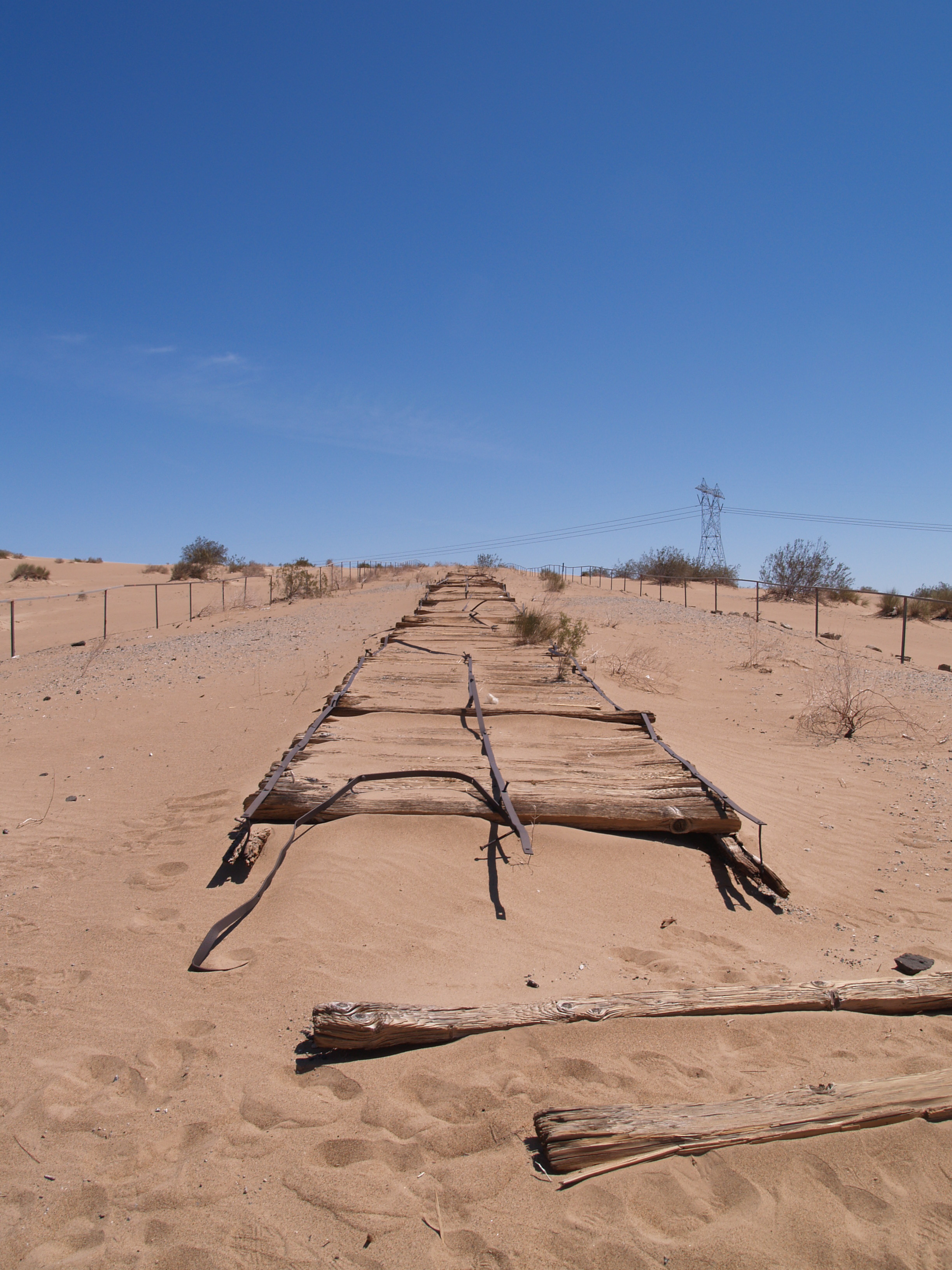
In the Times article you will see an excellent map & an illustration showing its travel path and how the railroad installed a metal barrier in the ground, trying to stop it. The geyser just dove underground and came back up on the other side of the barrier.

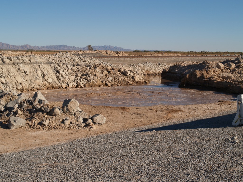
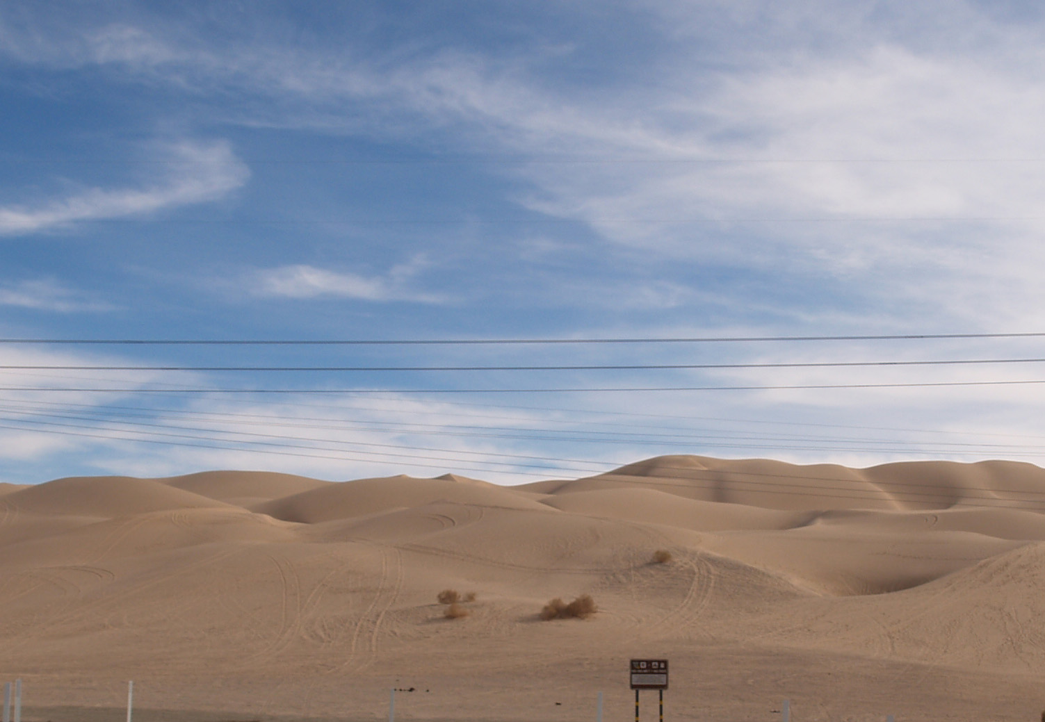
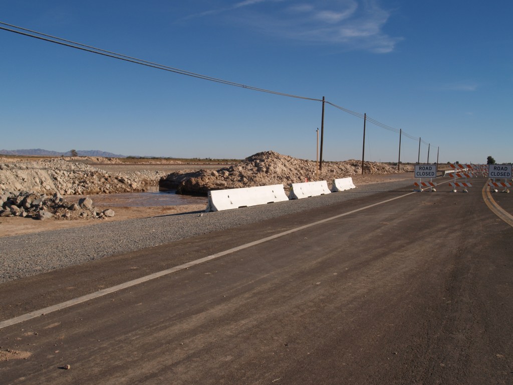
Last week I went again and took these photos. The mud pot is now about 35 feet from the asphalt edge of State Highway 111. Traffic is now routed on a bypass, just to the west (https://dot.ca.gov/caltrans-near-me/district-11/current-projects/sr111-nilandgeyser). I was able to park just north of the bypass and walk down the “real” highway to the site of the mud pot. Although there are three low concrete barriers, you can easily walk around them.

Union Pacific rail line can be seen behind the mud pot; the channel cut in the side of the circle drains the water to go under the road.

Will it continue it’s journey to the west? Into the Salton Sea? Only time will tell.

This year has been a struggle for many of us; I am hoping to get back to HistoryTrove more often. This post is a change of pace, but needing to get out and go somewhere that I wouldn’t meet anyone, this trip was perfect.

The First Salton Sea

Prehistorically, the Gulf of California extended north through the Imperial and Coachella Valleys; over time geologic shifts and water borne silt changed the topography of the land near the Mexican Border, cutting it off from the Gulf to create the Salton Sink. Subsequently, the Colorado River would change course, on and off creating a vast inland sea, now called Ancient Lake Cahuilla. Around 1580, the last vast lake evaporated.

Tufa deposits mark the shoreline of Ancient Lake Cahuilla, Coachella Valley

Before construction of Laguna Dam in the early twentieth century, the Colorado was still an active river, draining much of the Western US. Springing from watershed high in the snowy Rockies, the “Red River” raced southward and downward, carving the Grand Canyon and other marvelous canyons as it dashed on to the Sea of Cortez. As it approached the Gulf of California, the landscape changed, leaving behind the rock canyons and allowing the river to meander, creating an alluvial delta with the material carried downstream. Captain J. H. Mellon, who operated steamboats on the Lower Colorado, estimated the silt extended the delta fan into the Gulf by more than 6 miles over the course of the 40 years prior to 1905. (H.T. Cory, The Imperial Valley and The Salton Sink, Part IV, (John J. Newbegin, 1915), a reprint of Irrigation and River Control in the Colorado River Delta, from Vol. LXXVI, Transactions American Society of Engineers, p. 1214.)

Smaller overflows of the Colorado River banks continued into the nineteenth century, down the New and Alamo River channels, flowing into the Salton Basin and duly evaporating.

The winter of 1890/91 was the wettest since readings began being kept in 1850. In February, 1891, a number of breaks in the west bank of the Colorado allowed water to spill over into the delta and the New River channel. In June, when Spring runoff brought high water again, more water spilled into the streams running north into the Salton Trough reaching Salton, site of the New Liverpool Salt Works.

From The Californian: Illustrated Magazine, Vol. I, No. 1 October 1891.

The sea was approximately 40 miles long and 10 miles wide, but only 4 feet deep. (B. A. Cecil-Stephens, “The Colorado Desert and its Recent Flooding,” Journal of the American Geographical Society of New York, Vol. 23 (1891), pp. 367-377)

In July 1891, the New York Times printed remarks by John Wesley Powell, Director of the U.S. Geological Survey, that even if the lake were filled to the level of the river, it would evaporate at the rate of approximately 6 feet per year.

In 1892, a wood engraving (based on the Cecil-Stephens map) was published in La Nouvelle Géographie universelle, la terre et les hommes, 19 vol. (1875-94), text by Elisee Reclus. The Cartographer was Charles Perron (vol 16, pg 575). A hand-colored copy of the engraving is shown here.

The first Salton Sea did indeed evaporate due to the extreme heat and lack of sufficient incoming water sources. The situation was totally different following the 1905/07 flooding, as the entire river was diverted into the trough creating the lake, and runoff from agriculture in the Imperial Valley provided a new source of water to replenish that lost to evaporation.

For information on the 1905/07 flooding that created the current Salton Sea, my blog page Creation of the Salton Sea has a preview of a book I’ve written. historytrove.com/creation-of-the-salton-sea/

Araz Junction Revisited

Stage Depot as identified by California Division of Highways

I have found a real picture photograph (courtesy of the Eastman Collection, Univ. of Calif. Davis, circa 1940s) that shows the adobe building identified as the stage depot erected in 1856. At the time this was taken, the building as adjacent to US Route 80 (now designated as Historic U.S. Route 80 by California). See blog below for current photos.

The Plank Road on the Coast to Coast Highway

From the Los Angeles Chamber of Commerce Collection: “University of Southern California. Libraries” and “California Historical Society”

Not as obscure as some of the other sites, the plank road through the Algodones Sand Dunes of southeastern California, along with the first bridge across the lower Colorado River, allowed the completion of the Coast to Coast Highway (later US 80).

Prior to the late Nineteenth Century the common way to travel from Yuma to the California coast was via northern Mexico. Between the sand dunes and the lack of water, passage north of the border was virtually impossible. From Yuma, the Southern Pacific tracks (Indio to Yuma opened in 1877) turned north shortly after entering California, and ran on the east side of the dunes, rather than crossing what became the Imperial Valley. Irrigation and the resulting agricultural boom in the valley led to people wanting to traverse it, but by train the route required a loop south from Imperial Junction (later Niland) across the valley into Mexico at Calexico, east below the border approximately 50 miles, then north to Araz Junction to rejoin the SP mainline.

Sand Dune field near Interstate 8

In 1915, completion of the Coast to Coast Bridge crossing the Colorado at Yuma and the one lane Plank Road across the dunes enabled vehicular travel on the US side of the border. Originally just two 25″ parallel “tracks” of wood, about a year later, the planks were fastened together in a full 8′ lane as shown in the photos. When the shifting sand drifted over the wood, sections were moved by horse drawn rigs. Turn outs, approximately a quarter of a mile apart, allowed traffic to pull to the side and allow the driver traveling the other direction to pass, sometimes resulting in arguments over right of way.

Bureau of Land Management photo

By 1926, highway construction engineering had advanced to the point that an asphalted concrete road could be built replacing the Plank Road. To see a short stretch of a replica of the original road and the Historical Marker, take exit 156 off Interstate 8, turn west on Grays Wells Road; the site will be on the left side of the road, off a parking lot.

Path of the Plank Road near I 8

VALLECITO: A STOP ON THE BUTTERFIELD STAGE LINE

Vallecito Stage Station today

In a remote part of eastern San Diego County, turn south off Highway 78 onto The Great Southern Overland Stage Route (S2) to Vallecito County Park and Stage Station.

Starting with the first known visit by the Spanish in 1781, the oasis at Vallecito became an important stop for Spanish and later Mexican travelers to Alta California; between there and the Colorado River loomed the deadly desert. On November 29th and 30th, 1846, General Stephen W. Kearny and the Army of the West camped in the little valley according to the research of the Kearny Trail by Arthur Woodward (curator of history, Los Angeles Museum; The Kearny Trail Through Imperial and San Diego Counties, manuscript 1931). Subsequently an army supply depot was established, but it was abandoned in 1853.

The original building was expanded by James and Sarah Lassator and their family, and became a stop on the San Antonio-San Diego Mail Line.

In 1858, the Butterfield Overland Mail began its famous passenger stage service from St. Louis, through Yuma, and Vallecito became a “home” stage station where passenger meals were served and horses were changed. The Civil War led to the end of the Butterfield service, but the building continued to serve as a station on other stage lines, only to be abandoned after the railroad was completed from Los Angeles to Yuma in 1877.

In 1919, J. Smeaton Chase published an account of his travels on desert trails, including a photo of the crumbling Vallecito stage station, which he described as:

At the lower end of the valley some arrangement of the strata brings moisture to the surface to form a ciénaga, with a few mesquites and much salt grass and sacation. Near by stood the long-deserted stage-station, …of what at first sight I took to be adobe bricks of the usual kind, but found were blocks of natural sod from the ciénaga. It is the only structure of the kind that I know, and the material appears to answer its purpose well, better in fact than adobe….

Chase, California Desert Trails, p. 247
Chase, California Desert Trails, p. 248

In 1934, the station was reconstructed of sod (today it is part of the San Diego park system, with primitive campsites available).

Reconstructed sod building

As a young woman the artist, Marjorie Reed (1915-1996), became a friend of Captain William Banning (1858-1946), son of Phinneas Banning. In his obituary, The Los Angeles Times (Jan. 28, 1946), reported that “his lifelong hobby, [was] the Concord coaches which he drove as a boy on western transport lines owned by his father…” Reed was so inspired by the Banning’s tales that she devoted much of her art to the Butterfield stage line and its stations; below is one of her paintings of Vallecito as it must have looked on a mid-nineteenth century night.

Vallecito Stage Station by Marjorie Reed, from the author’s collection

Laguna Dam & Swastika Bridge

OLYMPUS DIGITAL CAMERA

Sluiceway of Laguna Dam, 2017                                                                                photo by author

Construction of Laguna Dam, the first dam across the Colorado River, began in July 1905; plagued by contractor and supply problems, plus flooding, it was completed in March 1909. During its planning, core samples had shown the dam site was layer upon layer of silt carried down by the river over the ages, so a conventional dam design could not be used. US Reclamation Service engineers ultimately based the design on a weir dam on the Jumna (Yuamna) River in northern India that was successfully built on silt (USBR, 1902-1923, was the predecessor to the US Bureau of Reclamation).

BOR Pictures 180
Laguna Dam from California side, circa 1910                              US Bureau of Reclamation photo,                                                                                                                                     National Archives

Located north of Yuma, its principal gate (bottom width 116′) was built on the western (California) side of the river to divert water into a canal that carried water down the western side of the River until it was opposite the town of Yuma, where it was directed into a twelve foot siphon that went under the River to carry irrigation to the Yuma Valley in Arizona. Water was also diverted to Fort Yuma Resesrvation and the Bard Valley in California.

view-into-siphon

“Ground hags” working in the siphon during construction                                                                                          US Bureau of Reclamation photo, National Archives

Connected by a weir dam across the river bed that raised the water level 10–13 feet, on the eastern side was a smaller gate (bottom width 42′) and canal to carry water to agriculture in Arizona along the Gila River. Both sluicegates were based on bedrock & paved with concrete.

usbr1

View of the Colorado River at Laguna today; California sluiceway is on the left.  The white stretch of concrete across the river bed is the wier dam; the Arizona gateway is not visible to the left of the photo.  The man-made “river” to the right is the All American Canal.                                                                                                    US Bureau of Reclamation photo, Yuma project.

LagunaDamArizonaSluiceGate

Sluiceway on the Arizona side, April 4, 1909.                                     US Bureau of Reclamation photo


OLYMPUS DIGITAL CAMERA

Sluiceway on the Arizona side, today.                                                                                photo by the author

According to the Arizona Sun (2/2/2013), while studying Indian dam construction, the US Reclamation Service also learned about an ancient Hindu Goddess, who had the power to control water and was sometimes represented by a four armed swastika, a symbol that had a history of peace in many cultures going back 9,500-10,000 years; it was not until the 1930s when the Nazis adopted the symbol that it came to stand for evil. Near the eastern gate they built a concrete bridge adorned with swastikas (whirling counter-clockwise) and also some were incised on the sluiceway.

IMG_0199


Swastika Bridge on the Arizona side                                                                           photos by the author


In 1948, Imperial Dam replaced Laguna as the means to divert water to the Yuma Valley (as well as to the new All American Canal). Since then Laguna has served as a sluice gate and regulator for Imperial Dam releases through the main river channel to Mexico.

Much of the infomration in this segment is based on US Bureau of Reclamation and National Park Service sites, and articles in Engineering News, (February 27, 1908 & June 10, 1909) by Edwind D. Vincent, USBR Resident Engineer, Yuma Project.


Araz Junction: Butterfield Stagecoach Station?

OLYMPUS DIGITAL CAMERA

There is some dispute over what this adobe ruin was. Many list it as a station on the Butterfield Stagecoach Line, while others dispute this claim based on there being no historical marker, no protection for the ruin, no “Araz Junction” Station on the stage line maps, and it being too small.

Balanced against those arguments is the fact there was a Pilot Knob Stage Station in the Second Division in California, between Fort Yuma and Los Angeles. The ruins are located north and slightly east of the Pilot Knob formation, which in the mid-nineteenth century would have been one of the few landmarks around.

OLYMPUS DIGITAL CAMERA

Pilot Knob seen from the northeast

I know of no other ruin or site in the area identified as the stage station location. Whether it was a stage station, or a storage building for a station or local mine, it remains a haunting reminder of our Western heritage.

OLYMPUS DIGITAL CAMERA

In 1877, the Southern Pacific finished building its main line linking Los Angeles and Yuma. In the early 1900s, the Inter-California railway was begun, to branch from the Southern Pacific mainline at Niland (then Imperial Junction) south to Calexico and then west via a loop through Baja California, to rejoin the SP mainline at Araz Junction.

In 1906, during the flood creating the Salton Sea, the SP built a spur line from Araz Junction south to the break in Colorado River (in Mexico), forming part of the ultimate Inter-Cal line. So, whether Araz Junction was the site of the Pilot Knob Stage Station, or not, it did play a significant role in the development of the Southwest. The branch line south was abandoned in the 1960s, but the mainline remains.

OLYMPUS DIGITAL CAMERA

Main rail line from Araz Junction ruin, 2017

To get there: Near the California/Arizona border, just west of Winterhaven, take exit 166 from I8 onto CA-186N. The adobe will be on the right side before you enter Winterhaven.  All photos in this post are by the author.